
15 April 2011 (330 km) - Pachacamac (Camp at Peru mountain biking champion's house)
After waking up and having a yarn to Pedro, the painter at the soccer stadium, I tucked off into the dirt and onto the tarmac of the Panamericana and headed north to Pachacamac, just south of the capital Lima. There were some ruins here I hoped to check out and find a camp nearby. On the way I stopped in at a lagoon in the middle of the desert in the town of Huacachina. It looked great seeing this pool of water amongst the sand dunes. A little touristy and what not but still nice. Available here were dune buggy and sand surfing tours but I decided to head on. I'd dropped a riding glove at one stage here and the guy who found it tracked me down to return it! Champ! I just thought he was trying to sell me something!
I kept heading north and took a break to check out the sights at Paracas Peninsula. A peninsula similar to Valdes Peninsula in Argentina, but much smaller. It was amazing riding with flat sands and dry hills. There WERE sea lions here but not now. I bumped into a guy who'd just collected some abalone in the morning while I was looking for the Candelabra. Man what a mission it was to find this place! The Julio C Tello museum here was still closed for reconstruction after the 2008 earthquake which wiped out a lot of the town of Pisco nearby. I eventually made it near Pachacamac and bought some food and fruit for dinner (as my stove is shat currently). I found a security guard in a truck and asked where I could camp...eventually he said follow him to the river. So I did...
We were driving down the road in a nice suburb when a few cars had blocked the way. I local was out trying to figure out why there was black smoke in the valley, as the area is an important ecological zone. The guy came over to me and introduced himself. I told him I was following the security dude to a camp near the river. He said though that there wasn't much there and instead I was welcome to camp in his yard which was surrounded by a big concrete wall with a mighty nice gate. Turns out this guy, now known to me as Alfonso, was and is a mountain biking champion in Peru. He also runs an eco farm which feeds his restaurant. I dined and shared some tales with them and met some friends from across the road...who very kindly gave me 3 cigars when I mentioned my celebratory cigar story. (These three were smoked in Otavalo at a raptor sanctuary, in Cartagena on the patio in Colombia and the Caribbean San Blas Islands in Panama. Cheers!) Alfonso still does tours in the hills nearby (10,000 ft or more) with more experienced riders and is often called open to help in rescues in the area as he knows the trails so well. Muchas gracias Alfonso y famillia!
Alfonso's eco restaurant can be found at Lote 67, Calle 8, Casa Blanca, Pachacamac. I highly recommend going and supporting eco friendly eating by buying a meal there! Check the website out at www.dontorcuatoperu.com
Huacachina...the beautiful desert retreat.

Paracas Peninsula photos...

Beautiful riding here!


These birds were nesting on the cliffs. Sweet as!

This bloke had spent the morning diving for abalone.

The hard to find Candelabro on Paracas Peninsula.

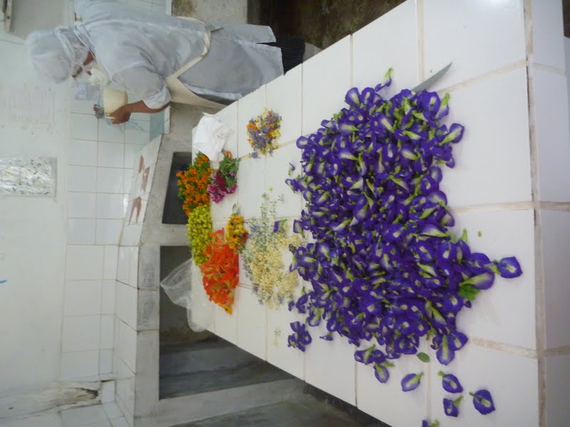
Alfonso's eco garden.

I got the total tour. These flowers are all edible!!! Used in pretty salads and the like.
16 April 2011 (356 km) - Cajamay (Camp)
I visited the Pachacamac temple that morning after leaving for an archeological fix. A sweet temple with many other ruins around it. Poor Nessie had been flogged out by the dirty Aussie riding her again and she needed a new rear tyre before I headed to the mountains for some nice dirt riding! Alfonso gave me the numbers of some guys in a suburb outside Lima who could show me to a shop. The guys gave me some stickers and a t-shirt to go! I eventually found the shop and popped on a new Pirelli MT60 (130/80) for about $80 AUD. With some new rubber I passed through Lima on the autopista (freeway) and headed for the mountains and the Cordillera Blanca! The Cordillera is the highest mountain range outside of the Himalayas. It was evening and I'd pulled into town as it started drizzling and asked where I could camp. I was shown a place but it was very open and near the main road so I ducked back down the road a few k to an abandoned shack on the road and camped inside, next to my girl Nessie. Safe and sound.
Alfonso with his two boys.

Pachacamac ruins. This was the Sun Temple.

The ruins were right by the Pacific. Nice place to perform rituals I guess! This was the view from the Sun Temple.

This is the living area at the ruins were old houses were.

A ramp serving an old temple.

The view from the highway.

I stopped to get some roadside tucker here! Good grub. Chicken and potatoes!

And then followed it with some fresh pawpaw and pineapple juice. As I went to sit down on the stool I fell flat on my donkey...the kids loved it!

Drying chillies.

17 April 2011 (310 km) - Ranch (Camp)
There were some ruins nearby at Chivan de Huantar. The roads there were high and cold, especially when it started raining. Some nice ruins, but nothing particularly flash, especially after seeing some larger ones down near the coast. I was now in the mountains again at about 3000-4000m so it was pleasantly cool. I made it back eventually to Huaraz in the Cordillera Blanca area and headed north. I found a ranch and restaurant on the left as I was heading north towards Yungay (about 14km south of Yungay it was) and asked to camp there. All was fine and there was even a pool with slippery slide and some animals and a creek to checkout. He let me camp for free so I bought a beer and gave him a tip. Later on a teenager and a kid came to chat. The kid wanted to buy my camera and the teenie was asking all about how to get to China to study Kung Fu. It was a nice quiet night of rest before a big 2 days ahead!
The location of the ranch is S 09.22001 and W 077.68856 and is at 2495m.
My first view of the Cordillera Blanca.

The main part of the ruins at Chavin de Huantar

18 April 2011 (247 km) - Pimi Pampa? (Camp)
The next 2 days were going to be very long days with not many kilometres. I started out nicely on the tarmac making some easy distance at turned to the mountains at Yungay.
This is the best road I've ridden in South America.
At Yungay I headed east into the mountains to checkout 2 lagunas 27 km up the road in a National Park. It was well worth the drive with an ampitheatre of mountains and cliffs surrounding 2 pristine fluorescent turquoise lakes. After snapping some pics and riding around I headed back down to Yungay and then north to Caraz. Here I bought some lunch and a new cord for the GPS as it was dieing again. Then I headed further north through the AMAZING Canon del Pato (duck canyon) and to Huallanca. To pass through the steep cliffs walls of the canyon meant driving through 30 or more tunnels and several huge waterfalls. The first tunnel I lost my vision as I was riding with sunnies and my lights couldn't give enough light to the pitch black tunnels blown into the mountains. I grabbed some bottled gasolina when I made it to Huallanca and headed off down the dusty dirt road where I would spend the next couple of days riding all day for only a few hundred clicks. And very worth it! The turnoff to La Pampa was at Huacachiri over a bridge. I headed up the winding road and had gained nearly a 1000 m in half an hour! The landscape was blank. Dry red and brown soil mountains...but astonishing views and beautiful! I'd made a few clicks on the upper plateau where it started getting green and muddy again when I came to a problem. They were repairing the roads and there were several mounds of sand on the road spanning from the right cliff to the left dropoff (the roads were cut literally into the side of cliffs and steep mountains).
As I started pondering my plan of return or attack...along came Polly! A mototaxi with a personal entourage came roaring down the one lane dirt road. Within a few minutes the entourage had cleared enough space for the mototaxi (an adapted moto with 3 wheels and a small passenger booth) to pass through...and me! Talk about lucky timing!!! So I pushed on. I was taking in the scenery and going around a one lane curve when all of a sudden there was a bus coming at me! We both hit the skids and managed to come to a stop headon with about a metre to spare! That was a close one! From here on I beeped on corners like I was an Indian taxi driver in a city. Eventually I made it over another pass and was greeted by a beautiful valley with villages on either side. I asked in the first village to camp and the pushed me on to the next one on the other side. After about an hour of riding I arrived and pulled into the main square. There was a dance party going on in a building next to the square and I asked some guys on a moto where I could camp. I saw a flat area from the otherside of the valley and hoped I could camp there. Within a few minutes of talking, I was surrounded by about 30 locals all checking out the gringo! Eventually I followed an older bloke and he let me camp in his yard next to his house. The bloke asked if I had some lollies for the kids, so I gave them some bananas (I had no lollies and don't like promoting teeth rot anyway!). I tucked in eventually for a rainy night in the tent. Ol mate had kindly put some plastic over the bike during the night.
One of the two lagunas above Yungay


Potholes anyone? And this one isn't too bad!

Drying corn outside a house after boiling it in the cauldrons.

The tunnels and view at Canon del Pato.


You can just see a tunnel in this photo.

Above Huallanca.

The roads leading through the valley. I'd just come from down there.


The road block and my saviours!

Cliff riding...don't F up.


The village you see is where I stayed for the night in the guys yard.

And the kids that followed me to the house. I gave them bananas. The healthy alternative to lollies!

19 April 2011 (238 km) - Huamachuco (Hostel Julian)
I left town at about 7am and headed off after checkin out some small ruins in the town. I passed through Llapo, Cabana, Mollepata, Lomina-Comarsa and San Simon...asking for directions every couple of kilometres just about. There were no maps or GPS routes up here! Lomina-Comarsa was a mountain which had been chopped apart in search of gold and there were some new dirt highways feeding the towns ahead. It was nice to finally reach some big dirt roads after spending most of the day before and most of today and tiny dirt, winding, cliff roads. I paid a ridiculous price for gas just before Cabana (2 bucks a litre) and then found cheap gas in Cabana about 20 km later! I pulled into Huamachuco on dusk and was about to camp when I saw how beautiful the square was. A reward for sure. It was Semana Santa (Easter week) and there was a mighty parade at night time. Fantastic!
The views in the mountains on the way to Huamachuco.

The roads were one laned and just cut into the mountains. It made for beautiful views and very slow driving!

Landslides can be a problem though with this road design. This bus wasn't going anywhere. The guys stayed with it and cleaned it in the meantime until they found a solution.

That's not grass growing on the road! They are arses carrying grass to this guys place!

One of the many beautiful creeks I had to cross.

These pigs know where tucker is it seems as they banged away at the door. You see they must do it often as the door has many marks from them!

A little bit more mud, water and fog to add to the excitement.

A nice mountain top village.

I'm a kid...I know. It's still funny though...

I had to leave this mountain, go downnnnnnhill, then come back up the otherside. WOOHOO!

Finally made it to the beautiful Huamachuco on sunset.

20 April 2011 (233 km) - Banos del Inca (Camp)
Today I was back on the bitumen! I made it to Cajamarca where the last Inca Atahualpa was imprisoned and killed by the Spanish Conquistadors. I left town to check out the more touristy but less impressive ventanillas de Otuzco. The more glorious ones are another 20 km down the road and entry is free. The ventanillas (windows) de Combayo were much more impressive and I parked my bike in a farmers yard and strolled across his cow paddock to check them out! It is believed to be a funerary complex due to the amount of bones found lieing around. After this I headed to Atahualpa's bathing and hangout area...Banos del Inca (bathroom of the Inca) and the guys at one of the hot baths let me camp INSIDE the complex UNDER the building and OUT of the rain! I headed over to the other hot pools and had a spa and a massage for about 7 bucks! Fantastic rejuvenation. I grabbed some spicy stomach to fill mine and headed home for a nap.
An old church...somewhere?

Ventanillas de Combayo

The road out to Ventanillas de Combayo.

Banos del Inca.

I had a much needed hot spa and massage! A great break from the road!

Nessie tucked in at Banos del Inca.

A typical south American scene. A lady carrying a baby on her back. A motorbike racing by. Kids playing soccer. And a beautiful sunset.

Atahualpa the last Inca.

21 April 2011 (296 km) - Near Santa Maria (Camp)
Bitumen led my path East until Encanada. I was headed for near Chachapoyas to the Kuelap Fortress...the northern equivalent of Macchu Pichu. On the way I stopped in a town square and some youngins polished my boots for a couple of bucks. Cheers lads! They needed it! I made it over another beautiful dirt road pass and back down one side into a dry Mexican lookin valley with a dirty river running through it. It was bright outside. I finally came to the bridge crossing the river and had made my way across it. I was entering a small village at the end of the bridge with nice shady trees over it. Not going over fast or slow, I was too slow to see the steel pole across the road at chest height! With metres to spare I smashed right into it bouncing it forward and then back up, smashing into my helmet. I lost balance and dropped the bike. The people in the square got a great show and I'd picked up the bike by the time the police guard had come over to see if I was OK. Apart from a slight headache I was fine and got going again. I guess it was because of the sudden change in light that I didn't see the DARK pole (used as a stop for police) and decided to test its strength! I made it near Kuelap Fortress and found camp in a horse paddock under a house.
Another mountainous climb on the way to Kuelap Fortress.

The bride I crossed. The pole I smashed into. The police officer that stood there.

I was lucky with landslides the whole trip. I never had to turn around because of one and was only delayed maybe 10 minutes at most for some.

A while ago I was in the town hitting a pole!


22 April 2011 (184 km) - Cocachimba (Camp)
After a 20 km ride up the mountains I arrived at Kuelap Fortress. I spent a couple of hours checking it all out eventually headed back down and north. I decided to take a detour to check out Karaja, some other archaeoligcal statues. I was riding there and the road kept on getting thinner and steeper and eventually I dropped Nessie! It was time to leave her there and walk the rest. A group of people sitting in a field had watched me drop the bike and then struggle to stand her back up. Another show for the public! I was walking by and the invited me in for some potatoes! Fantastic! I was starving. They were digging up their fields so gave me some tucker they'd left over from lunch. The statues were cool but much smaller than they looked in pictures and not quite justifying the couple of hour detour. I eventually pulled in to Cocachimba to check out the massive Gocta Falls which dropped over 3 levels from the plateau above. After a 4hr walk/jog there and back (people will say 6 hrs) I camped at a restaurant for the night.
Kuelap Fortress.

It's well protected...or was.

It sits high atop this mountain.

There were only 3 entries into the fortress. All were like this. Long walkways and high. Making it very hard for any possible intruders to rampage through quickly.

This building was rebuilt as an example.

The entrance showed in the previous photo.

These were tombs. I asked if they were toilets...

For mum!

These patterns were beautiful. Houses in nearby villages had similar markings painted on the outside. This is definitely where "Umbro" got their symbol.

Apparently these trees were also not here thousands of years ago. These ruins were pre-Incan.

The views on the way to Karaja.

The potato farmers who gave me some tucker.

Karaja...see the statues?

The Gocta Falls from afar.

One section of the Gocta Falls

A local guy showing me an orchard on my walk back from the falls. This one is for you Mum! Unfortunately I couldn't bring it home.

23 April 2011 (? km) - Zumba (Pension Saracay)
Finally today I was to push for the border of Ecuador. I headed off and on my way north checked out the Pongo de Rentema (Rentema Canyon). It wasn't anything too special also for the big detour it took, however on the way back I got a neat photo with some road guards. I was also stopped by 20 police at a checkpoint. Apparently on this road there are heaps of assaults. Hence the police and checkpoints with shotgun-wielding guards. Eventually I made it up to San Ignacio and to the border just past it in the mountains. It was a beautiful drive through lush rainforest on dirt roads. Upon arriving at the border the Peruvian Aduana (customs) officers were drinking and singing karaoke (Semana Santa still) and the migration officers were missing. Apparently they were on the side drinking with their boys! An easy and pleasant border crossing and I was on my way to Zumba where I found a nice place to stay at Pension Saracay for 2 bucks a night!
These kids were on school camp to see the Gocta Falls and came over for a morning yarn and question time while I packed the bike.

Found this guy on the road to San Ignacio. He was slower than I expected!

First I asked for a photo of them with my bike...

Then I asked if I could be in it with a shotty!

Rice fields in the valley and the tractor on the right with steel wheels ploughing the fields.

Turkey vultures.

San Ignacio

The Peruvian border migration girls...MIA on the Ecuadorian side with their boys.

These guys asked me to pump up their ball...and everyone wanted to check the pressure...including the Aduana guy!

Until next time. Feliz dias!
I like it!!!
ReplyDeleteI miss my country Peru!!